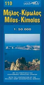
Wegenkaart - landkaart 110 Milos Kimolos | Road Editions (9789608481305)
- ISBN / CODE: 9789608481305
- Editie: 22-08-2008
- Aantal blz.: 1
- Schaal: 1:50000
- Uitgever: Road Editions
- Soort: Wegenkaart
- Taal: Engels
- Hoogte: 25.0 cm
- Breedte: 13.0 cm
- Gewicht: 85.0 g
- Uitvoering: Papier
- Beoordeling: 5,0 ★★★★★ (1 review) Schrijf een review
-
€ 9,95
Leverbaar in 3 - 5 werkdagen in huis in Nederland Levertijd Belgie
Gratis verzending in Nederland vanaf €35,-
-
Overzicht Eilanden groepen indeling


Producten op deze overzichtskaart:
Klik op een product om naar de pagina van dat product te gaan.
- Wegenkaart - landkaart 101 Andros | Road Editions
- Wegenkaart - landkaart 102 Tinos | Road Editions
- Wegenkaart - landkaart 104 Syros | Road Editions
- Wegenkaart - landkaart 105 Tzia - Kea | Road Editions
- Wegenkaart - landkaart 107 Serifos | Road Editions
- Wegenkaart - landkaart 109 Sifnos | Road Editions
- Wegenkaart - landkaart 110 Milos Kimolos | Road Editions
- Wegenkaart - landkaart 113 Ios | Road Editions
- Wegenkaart - landkaart 118 Spetses | Road Editions
- Wegenkaart - landkaart 201 Karpathos - Kassos | Road Editions
- Wegenkaart - landkaart 213 Lemnos | Road Editions
- Wegenkaart - landkaart 215 Samothraki – Samothraki | Road Editions
- Wegenkaart - landkaart 216 Skyros | Road Editions
- Wandelkaart - Wegenkaart - landkaart 218 Skopelos | Road Editions
- Wegenkaart - landkaart 303 Lefkada | Road Editions
Overzichtskaarten
Beschrijving
Gedetailleerde wegenkaart met aanduiding van de wandelwegen, lijst van hotels en toeristische informatie. Voor alle doeleinden een zeer geschikte kaart. Though not among the top ten most popular destinations in the Aegean, these are two beautiful islands with a unique character, ideal for quiet family holidays, and nature touring, as well as for the young crowd looking for exciting summer fun.
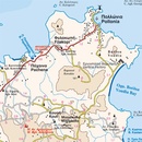
This is the best, most updated and easy to read map available of Milos and Kimolos. As all ROAD maps, it was designed following careful and exhaustive onsite research. We used the most advanced technology to precisely map the entire road networks of these two islands, we measured the distances in kilometers from intersection to intersection with precision instruments, marked all country churches, monasteries, archaeological sites and castles on these islands, as we did the beaches and the roads leading to them, the altitudes of mountain peaks, the footpaths we were able to locate and record, the location names as they are currently in use, the lighthouses, the airport of course and much more.
On the front of the map, we present the basic features regarding the history, important sights, beaches and modern day Milos and Kimolos in the form of brief texts, rendered in Greek and English.
We highlighted in green the scenic routes of the two islands, to allow you to enjoy the beautiful landscapes while driving.
The contour lines on this map (at 20m intervals), the coastline and the hydrography were provided by the Hellenic Military Geographic Service.
The back of the map is in colour and contains a complete listing of the accommodations available on Milos and Kimolos (including all the rooms to rent!), useful telephone numbers, information about the museums and local bus schedules and an interesting plan that will assist you if you visit the catacombs of Milos. There is also a map on which the locations of the mines are marked along with the types of minerals mined.
In addition to Milos and Kimolos, Poliegos and Antimilos are also presented and mapped, as are all the surrounding islets.
Reviews
We zijn uitermate tevreden over deze kaart. Hij is duidelijk en overzichtelijk. Het zal ons fantastisch helpen komende zomer onze weg te vinden op dit waanzinnig mooie eiland.
★★★★★ door H.M. Bos 3 december 2012Vond u dit een nuttige review? (login om te beoordelen)
Schrijf een review
Graag horen wij wat u van dit artikel vindt. Vindt u het goed, leuk, mooi, slecht, lelijk, onbruikbaar of erg handig: schrijf gerust alles op! Het is niet alleen leuk om te doen maar u informeert andere klanten er ook nog mee!


