Mandje Tel: +31503126950 Menu
Winkelwagen
Geen items in winkelwagen
Ga naar winkelwagen

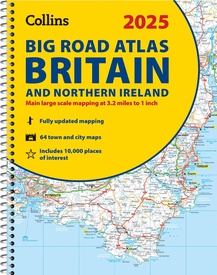
Wegenatlas Big Road Atlas Britain and Northern Ireland 2025 | A3 | Ringband | Collins (9780008652883)

Engeland - Schotland

  • ISBN / CODE: 9780008652883
  • Editie: 2024
  • Aantal blz.: 176
  • Schaal: 1:200000
  • Auteur(s): HarperCollins Publishers
  • Uitgever: Collins
  • Soort: Wegenatlas
  • Taal: Engels
  • Hoogte: 38.5 cm
  • Breedte: 30.4 cm
  • Dikte: 1.5 cm
  • Gewicht: 1000.0 g
  • Uitvoering: -
  • Bindwijze: RIngband
  • Beoordeling: 4,7 ★★★★★ ★★★★★ (3 reviews) Schrijf een review
  • 20,95

    Op voorraad. Binnen 2 - 3 werkdagen in huis in Belgie Levertijd Nederland Voor 17.00 uur op werkdagen besteld, morgen in huis in Nederland Levertijd Belgie

    Gratis verzending in Nederland vanaf €35,-

Beschrijving

Grote wegenatlas, a3-formaat in ringband.

The ultimate 3.2 miles to 1 inch scale large-format, spiral-bound road atlas of Britain, featuring Collins’ popular and well established road mapping, and designed for exceptional clarity and ease of use.
 
The atlas has a wide range of urban area maps at even larger scale and 64 detailed town centre street plans.
 
This fully updated road atlas covers the whole of Britain with each scale of mapping colour-coded for ease of use. The smallest scale maps are great for long distance route planning and the street plans help you locate your final destination.
 
Main features:
 
Easy to use, clear road maps at a scale of 3.2 miles to 1 inch of England, Wales and Southern Scotland. Northern Scotland is shown at 5 miles to 1 inch
Route planning section including maps at a scale of 15.8 miles to 1 inch, motorway services information and a handy distance calculator
22 urban area approach maps at 1 mile to 1 inch which clearly show the best routes through and into urban areas
64 street maps focused on town centres showing places of interest, car park locations and one-way streets
Updated Park & Ride locations, new rail stations and extensions to tram lines in Blackpool and Edinburgh
Over 30 categories of places of interest including castles, theme parks, sports venues and surfing beaches
Full postcodes for the top 1000 places of interest – ideal for use alongside sat-nav systems
Clean Air and Low Emission Zones explained and indicated on mapping


Reviews

Prima wegenatlas

Door de ringband en de schaal van de kaarten prettig in gebruik.

★★★★★ door Wilma 26 augustus 2024 | Heeft dit artikel gekocht

Vond u dit een nuttige review? (login om te beoordelen)

-
Nee (0)
Super voor op schoot

Groot wegenboek is super handig om mee te hebben op reis of roadtrip. Leuk om de bijrijder mee te laten navigeren of om trips samen te plannen. Aanrader !

★★★★★ door Geert Van Baezl 23 augustus 2024 | Heeft dit artikel gekocht

Vond u dit een nuttige review? (login om te beoordelen)

-
Nee (0)
Gedetaillerde kaarten

Uitgebreide en gedetailleerde kaartenboek

★★★★★ door Tom 13 augustus 2024 | Heeft dit artikel gekocht

Vond u dit een nuttige review? (login om te beoordelen)

-
Nee (0)

Schrijf een review

Graag horen wij wat u van dit artikel vindt. Vindt u het goed, leuk, mooi, slecht, lelijk, onbruikbaar of erg handig: schrijf gerust alles op! Het is niet alleen leuk om te doen maar u informeert andere klanten er ook nog mee!