Wandkaarten van continenten
Continentkaart kopen? Hang de wereld aan de muur met onze collectie continentwandkaarten
Met een continentkaart heeft u bijvoorbeeld een kaart van Afrika, van Europa of van Azië in uw huis hangen. De meeste van deze kaarten zijn zeer gedetailleerd, zo kunt u deze landen verkennen op uw muur, een reis plannen of een eerdere reis juist herinneren.
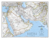 Wandkaart Middle East - Midden Oosten 76 x 58 cm | National Geographic
Wandkaart van het Midden Oosten, met o.a. Afghanistan - Pakistan - National Geographic wandkaart geplastificeerd - Afmeting ca 76 x 58 cm National Geographic Maps' recently updated wall map of …
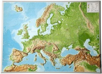 Wandkaart - Reliëfkaart Europa met voelbaar 3D reliëf, 77 x 55 x 2 cm | GeoRelief
De uitgever van de kaart is de bekende Duitse uitgever GeoRelief GbR. Deze topografische kaart van Europa heeft een hoge kwaliteit met prachtige kleuren (engelse versie). De kaart bevat de namen …
★★★★★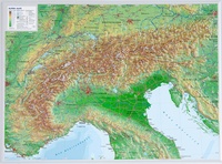 Wandkaart - Reliëfkaart van de Alpen met voelbaar 3D Reliëf, 77 x 57 cm | GeoRelief
De uitgever van de kaart is de bekende Duitse uitgever GeoRelief. Deze topografische kaart van de Alpen heeft een hoge kwaliteit met prachtige kleuren. De kaart bevat de namen van …
★★★★★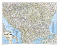 Wandkaart The Balkans - Balkan landen, 77 x 60 cm | National Geographic
Study the countries of the Balkans with our new map featuring the classic National Geographic reference styling. Features thousands of place names, accurate political boundaries, national parks, and major infrastructure …
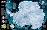 Wandkaart Antarctica Satellite Map, 78 x 50 cm | National Geographic
This digital mosaic of 4,500 satellite scans shows incredible detail of Antarctica's terrain. Includes insets that show the surface elevation, ice sheet thickness, ice flow velocity, and sea ice movement …
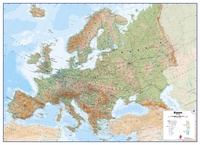 Wandkaart Europa Natuurkundig, 135 x 98 cm | Maps International
Maps International's large physical wall map of Europe is one of the finest money can buy. European Map details: Our large physical wall map of Europe features the natural …
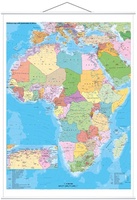 Wandkaart Africa – Afrika, 97 x 119 cm | Stiefel
Duidelijke, heldere kaart van Afrika. Geplastificeerd met metalen ophangstrips.Beschrijfbaar en afwisbaar. Wandkarte mit Metallbeleistung - beschreib- und abwischbar - extrem reißfest- - Ländergrenzen - alle wichtigen Städte und Hauptstädte - …
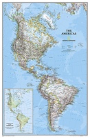 Wandkaart The Americas - Noord & Zuid Amerika, politiek, 60 x 94 cm | National Geographic
National Geographic's Classic style political wall map of The Americas features a bright color palette with blue oceans and the continents' terrain detailed in stunning shaded relief that has been …
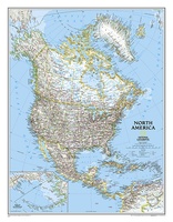 Wandkaart Noord Amerika, politiek, 60 x 77 cm | National Geographic
The political map of North America features trademark National Geographic detail and accuracy. The map shows country boundaries, place names, major highways and roads, bodies of water, and more. An …
 Wandkaart Noord Amerika, politiek, 91 x 118 cm | National Geographic
The political map of North America features trademark National Geographic detail and accuracy. The map shows country boundaries, place names, major highways and roads, bodies of water, and more. An …
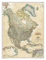 Wandkaart Noord Amerika, politiek & antiek, 60 x 78 cm | National Geographic
This richly colored map of North America - featuring country boundaries, place names, major highways and roads, and bodies of water - is excellent for reference in your home or …
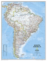 Wandkaart Zuid Amerika, politiek, 54 x 74 cm | National Geographic
This classic map of South America shows political boundaries, place names, airports, major roads and highways, and other geographic features for the entire continent.
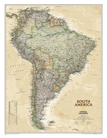 Wandkaart Zuid Amerika, politiek & antiek, 60 x 77 cm | National Geographic
This elegant, richly colored map of South America shows political boundaries, place names, airports, major roads and highways, and other geographic features for the entire continent.
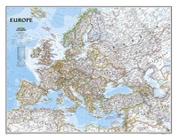
 Wandkaart Europa, politiek, 77 x 60 cm | National Geographic
This colorful Europe political map clearly shows country boundaries, capitals, many major cities, bodies of water, airports, major highways and roads, and much more.
 Wandkaart Europa, politiek, 114 x 88 cm | National Geographic
This colorful Europe political map clearly shows country boundaries, capitals, many major cities, bodies of water, airports, major highways and roads, and much more.
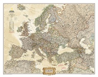
 Wandkaart Europa, politiek & antiek, 77 x 60 cm | National Geographic
National Geographic is a renowned authority in cartography. For 120 years the Society's maps have helped spread geographic knowledge around the globe. A vast database allows National Geographic to combine …
 Wandkaart Europa, politiek & antiek, 116 x 90 cm | National Geographic
National Geographic is a renowned authority in cartography. For 120 years the Society's maps have helped spread geographic knowledge around the globe. A vast database allows National Geographic to combine …
 Wandkaart Europa, politiek & antiek, 249 x 194 cm | National Geographic
Deze kaart wordt gemaakt in drie delen - te groot om in 1 keer te fabriceren met kans op beschadigingen - die vervolgens zeer nauwkeurig aan elkaar worden geplakt. …
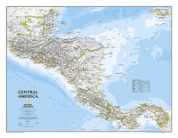 Wandkaart Centraal Amerika, 73 x 55 cm | National Geographic
This Central America Wall Map by National Geographic contains extensive political information with political boundaries clearly presented with different color-bands for each country. Beautifully shaded to show physical terrain, this …
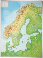 Wandkaart - Reliëfkaart Scandinavië met voelbaar 3D reliëf 77 x 55 x 2 cm | GeoRelief
De uitgever van de kaart is de bekende Duitse uitgever GeoRelief GbR. Deze topografische kaart van Scandinavië heeft een hoge kwaliteit met prachtige kleuren (engelse versie). De kaart bevat de …
Waar moet je op letten als je een goede wandkaart van een continent wilt kopen?
Welke verschillende soorten wandkaarten van werelddelen zijn er eigenlijk:
Van welke continenten zijn er wandkaarten?
Het formaat van een wandkaart van een werelddeel
De leesbaarheid van een wandkaart van een continent
Veel uitvoeringen van dezelfde wandkaart van een wereldeel
Hoe wordt de wandkaart verzonden?
Laatste reviews

Ideale schaal waar ook de kleinere wegen duidelijk zijn aangegeven. Beschrijving op website is correct.
★★★★★ door Peter 16 mei 2024 | Heeft dit artikel gekocht
Overzichtelijke kaart. Niks op aan te merken.
★★★★★ door Bastiaan de Leeuw 16 mei 2024 | Heeft dit artikel gekocht
Fijne overzichtelijke kaart. Niet veel op aan te merken!
★★★★★ door Bastiaan de Leeuw 16 mei 2024 | Heeft dit artikel gekocht
Voor het wandelen niet heel geschikt. Door het kleurgebruik zit er weinig contrast in en komt het erg donker over. Wat ingewikkeld oriënteren. Maar je …
★★★★★ door Bastiaan de Leeuw 16 mei 2024 | Heeft dit artikel gekocht