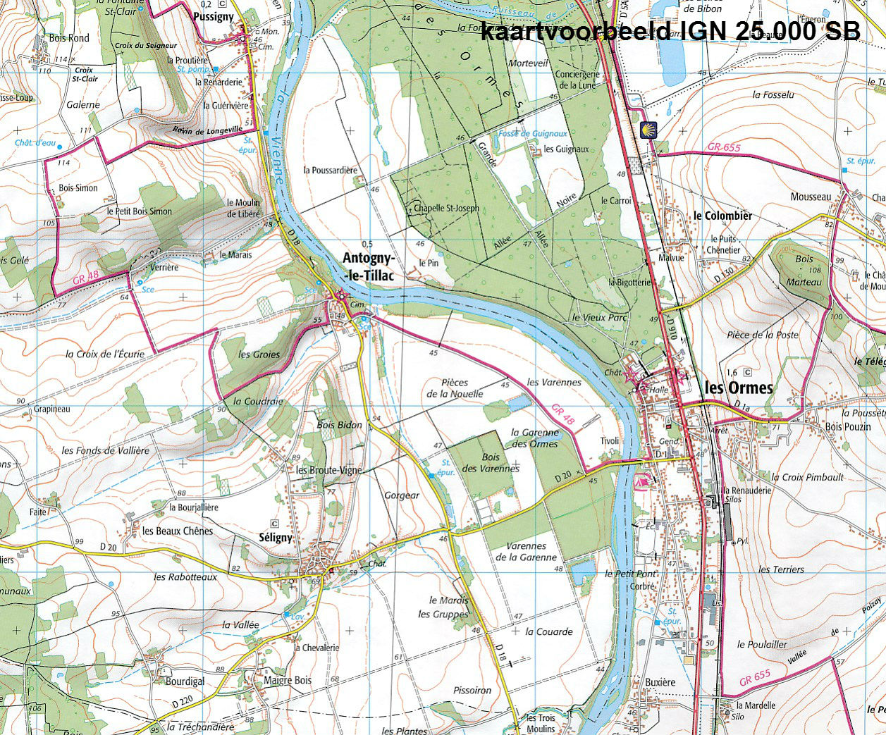
Wandelkaart - Topografische kaart 2924SB Arnay-le-Duc – Epignac | IGN - Institut Géographique National (9782758534518)

- ISBN / CODE: 9782758534518
- Editie: meest recente versie
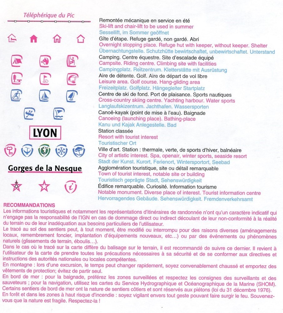
- Schaal: 1:25000
- Uitgever: IGN - Institut Géographique National
- Soort: Topografische kaart, Wandelkaart
- Serie: Serie bleue
- Taal: Frans
- Bindwijze: -
- Uitvoering: Papier
- Beoordeling: 5,0 ★★★★★ (1 review) Schrijf een review
-
€ 16,95
Leverbaar in 3 - 5 werkdagen in huis in Belgie Levertijd Nederland

-
Topografische kaarten IGN 25.000 Bourgondië: OOSTELIJK GEDEELTE + MORVAN

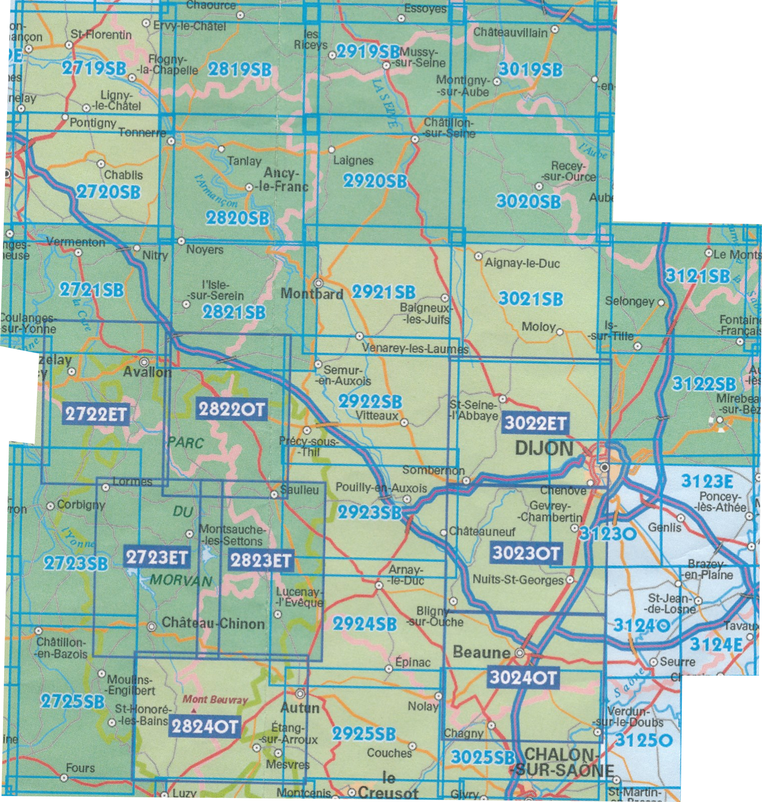
Producten op deze overzichtskaart:
Klik op een product om naar de pagina van dat product te gaan.
- Wandelkaart - Topografische kaart 2719SB Saint-Florentin – Flogny-la-Chapelle | IGN - Institut Géographique National
- Wandelkaart - Topografische kaart 2720SB Chablis, Champs-sur-Yonne | IGN - Institut Géographique National
- Topografische kaart - Wandelkaart 2721SB Vermenton | IGN - Institut Géographique National
- Topografische kaart - Wandelkaart 2722ET Avallon - Vézelay | IGN - Institut Géographique National
- Topografische kaart - Wandelkaart 2723ET Château-Chinon | IGN - Institut Géographique National
- Wandelkaart - Topografische kaart 2723SB Corbigny | IGN - Institut Géographique National
- Topografische kaart - Wandelkaart 2725SB Moulins-Engilbert | IGN - Institut Géographique National
- Topografische kaart - Wandelkaart 2819SB Chaource | IGN - Institut Géographique National
- Topografische kaart - Wandelkaart 2820SB Tonnerre | IGN - Institut Géographique National
- Topografische kaart - Wandelkaart 2821SB L'Isle-sur-Serein | IGN - Institut Géographique National
- Wandelkaart - Topografische kaart 2822OT Quarre-les-Tombes | IGN - Institut Géographique National
- Topografische kaart - Wandelkaart 2823ET Saulieu - Lac de Settons | IGN - Institut Géographique National
- Wandelkaart - Topografische kaart 2824OT Autun - Mont Beuvray | IGN - Institut Géographique National
- Topografische kaart - Wandelkaart 2919SB les Riceys | IGN - Institut Géographique National
- Topografische kaart - Wandelkaart 2920SB Châtillon-sur-Seine | IGN - Institut Géographique National
- Topografische kaart - Wandelkaart 2921SB Baigneux-les-Juifs, Alésia, Montbard | IGN - Institut Géographique National
- Wandelkaart - Topografische kaart 2922SB Semur-en-Auxois – Vitteaux | IGN - Institut Géographique National
- Wandelkaart - Topografische kaart 2923SB Pouilly-en-Auxois – Thoisy-la-Berchère | IGN - Institut Géographique National
- Wandelkaart - Topografische kaart 2924SB Arnay-le-Duc – Epignac | IGN - Institut Géographique National
- Wandelkaart - Topografische kaart 2925SB Autun - Le Creusot | IGN - Institut Géographique National
- Topografische kaart - Wandelkaart 3019SB Châteauvillain | IGN - Institut Géographique National
- Topografische kaart - Wandelkaart 3020SB Recey-sur-Ource | IGN - Institut Géographique National
- Wandelkaart - Topografische kaart 3021SB Grancey-le-Château-Neuvelle – Aignay-le-Duc | IGN - Institut Géographique National
- Wandelkaart - Topografische kaart 3022ET Val-Suzon - St-Seine-l'Abbaye - Dijon Ouest | IGN - Institut Géographique National
- Wandelkaart - Topografische kaart 3023OT Nuits-St-Georges | IGN - Institut Géographique National
- Wandelkaart - Topografische kaart 3024OT Beaune Chagny | IGN - Institut Géographique National
- Wandelkaart - Topografische kaart 3025SB Chalon-sur-Saone (Nord), Chagny | IGN - Institut Géographique National
- Topografische kaart - Wandelkaart 3121SB Is-sur-Tille | IGN - Institut Géographique National
- Wandelkaart - Topografische kaart 3122SB Mirebeau-sur-Bèze | IGN - Institut Géographique National
- Wandelkaart - Topografische kaart 3123SB Dijon | IGN - Institut Géographique National
- Wandelkaart - Topografische kaart 3124SB Seurre | IGN - Institut Géographique National
-
Wandelkaarten IGN 25.000 Bourgondië: OOSTELIJK GEDEELTE + MORVAN

Producten op deze overzichtskaart:
Klik op een product om naar de pagina van dat product te gaan.
- Wandelkaart - Topografische kaart 2719SB Saint-Florentin – Flogny-la-Chapelle | IGN - Institut Géographique National
- Wandelkaart - Topografische kaart 2720SB Chablis, Champs-sur-Yonne | IGN - Institut Géographique National
- Topografische kaart - Wandelkaart 2721SB Vermenton | IGN - Institut Géographique National
- Topografische kaart - Wandelkaart 2722ET Avallon - Vézelay | IGN - Institut Géographique National
- Topografische kaart - Wandelkaart 2723ET Château-Chinon | IGN - Institut Géographique National
- Wandelkaart - Topografische kaart 2723SB Corbigny | IGN - Institut Géographique National
- Topografische kaart - Wandelkaart 2725SB Moulins-Engilbert | IGN - Institut Géographique National
- Topografische kaart - Wandelkaart 2819SB Chaource | IGN - Institut Géographique National
- Topografische kaart - Wandelkaart 2820SB Tonnerre | IGN - Institut Géographique National
- Topografische kaart - Wandelkaart 2821SB L'Isle-sur-Serein | IGN - Institut Géographique National
- Wandelkaart - Topografische kaart 2822OT Quarre-les-Tombes | IGN - Institut Géographique National
- Topografische kaart - Wandelkaart 2823ET Saulieu - Lac de Settons | IGN - Institut Géographique National
- Wandelkaart - Topografische kaart 2824OT Autun - Mont Beuvray | IGN - Institut Géographique National
- Topografische kaart - Wandelkaart 2919SB les Riceys | IGN - Institut Géographique National
- Topografische kaart - Wandelkaart 2920SB Châtillon-sur-Seine | IGN - Institut Géographique National
- Topografische kaart - Wandelkaart 2921SB Baigneux-les-Juifs, Alésia, Montbard | IGN - Institut Géographique National
- Wandelkaart - Topografische kaart 2922SB Semur-en-Auxois – Vitteaux | IGN - Institut Géographique National
- Wandelkaart - Topografische kaart 2923SB Pouilly-en-Auxois – Thoisy-la-Berchère | IGN - Institut Géographique National
- Wandelkaart - Topografische kaart 2924SB Arnay-le-Duc – Epignac | IGN - Institut Géographique National
- Wandelkaart - Topografische kaart 2925SB Autun - Le Creusot | IGN - Institut Géographique National
- Topografische kaart - Wandelkaart 3019SB Châteauvillain | IGN - Institut Géographique National
- Topografische kaart - Wandelkaart 3020SB Recey-sur-Ource | IGN - Institut Géographique National
- Wandelkaart - Topografische kaart 3021SB Grancey-le-Château-Neuvelle – Aignay-le-Duc | IGN - Institut Géographique National
- Wandelkaart - Topografische kaart 3022ET Val-Suzon - St-Seine-l'Abbaye - Dijon Ouest | IGN - Institut Géographique National
- Wandelkaart - Topografische kaart 3023OT Nuits-St-Georges | IGN - Institut Géographique National
- Wandelkaart - Topografische kaart 3024OT Beaune Chagny | IGN - Institut Géographique National
- Wandelkaart - Topografische kaart 3025SB Chalon-sur-Saone (Nord), Chagny | IGN - Institut Géographique National
- Topografische kaart - Wandelkaart 3121SB Is-sur-Tille | IGN - Institut Géographique National
- Wandelkaart - Topografische kaart 3122SB Mirebeau-sur-Bèze | IGN - Institut Géographique National
- Wandelkaart - Topografische kaart 3123SB Dijon | IGN - Institut Géographique National
- Wandelkaart - Topografische kaart 3124SB Seurre | IGN - Institut Géographique National
Overzichtskaarten
Beschrijving
Reviews
Prima kaarten om een wandeling uit te stippelen, een bestaande wandeling te lopen of een stuk GR te verkennen. Ik kan niet zonder! De Zwerver heeft bijna alles in huis, en zo niet, dan doen ze hun uiterste best om de door jou gewenste kaart op tijd te bezorgen. Ook nu weer gelukt dankzij een zeer behulpzame en vriendelijke Eva!
★★★★★ door Peter Hunink 17 juli 2018 | Heeft dit artikel gekochtVond u dit een nuttige review? (login om te beoordelen)
Schrijf een review
Graag horen wij wat u van dit artikel vindt. Vindt u het goed, leuk, mooi, slecht, lelijk, onbruikbaar of erg handig: schrijf gerust alles op! Het is niet alleen leuk om te doen maar u informeert andere klanten er ook nog mee!
Ook interessant voor europa/frankrijk/bourgondie
-

Wandelkaart - Topografische kaart 24
€ 16,95Topografische kaarten Bourgondië - Morvan -

Topografische kaart - Wandelkaart 29
€ 16,95Topografische kaarten Bourgondië - Morvan -

Wegenkaart - landkaart 327 Loire - R
€ 9,95Wegenkaarten Bourgondië - Morvan -

Wandelkaart - Topografische kaart 24
€ 16,95Topografische kaarten Bourgondië - Morvan -

Reisgids Reise-Taschenbuch Burgund |
€ 18,50Reisgidsen Bourgondië - Morvan