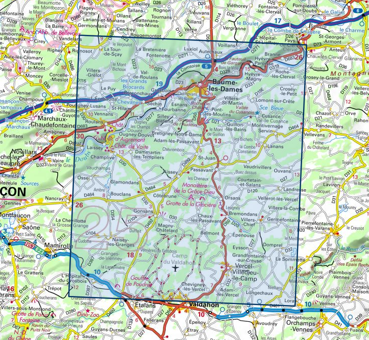
Wandelkaart - Topografische kaart 3423ET Baumes-les-Dames, Vallee du Doubs | IGN - Institut Géographique National (9782758550181)

- ISBN / CODE: 9782758550181
- Editie: nieuwste editie
- Schaal: 1:25000
- Uitgever: IGN - Institut Géographique National
- Soort: Topografische kaart, Wandelkaart
- Serie: Top 25
- Taal: Frans
- Schrijf als eerste een review
-
€ 16,95
Leverbaar in 3 - 5 werkdagen in huis in Belgie Levertijd Nederland

.jpg)
-
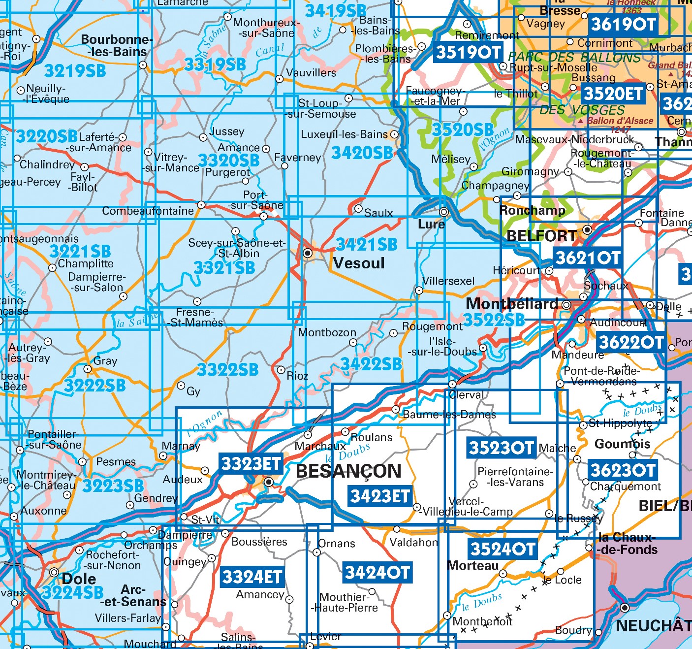
Topografische kaarten IGN 25.000 Jura : Noord

Producten op deze overzichtskaart:
Klik op een product om naar de pagina van dat product te gaan.
- Topografische kaart - Wandelkaart 3220SB Fayl-Billot | IGN - Institut Géographique National
- Topografische kaart - Wandelkaart 3221SB Champlitte | IGN - Institut Géographique National
- Wandelkaart - Topografische kaart 3222SB Gray - Autrey-lès-Gray | IGN - Institut Géographique National
- Wandelkaart - Topografische kaart 3223SB Pesmes - Gendrey | IGN - Institut Géographique National
- Wandelkaart - Topografische kaart 3224SB Dole | IGN - Institut Géographique National
- Wandelkaart - Topografische kaart 3319SB Monthureux-sur-Saône - Voisey | IGN - Institut Géographique National
- Wandelkaart - Topografische kaart 3320SB Jussey - Faverney | IGN - Institut Géographique National
- Wandelkaart - Topografische kaart 3321SB Port-sur-Saône, Fresne-St-Mamès | IGN - Institut Géographique National
- Wandelkaart - Topografische kaart 3322SB Gy - Rioz | IGN - Institut Géographique National
- Wandelkaart - Topografische kaart 3323ET Besançon - Forêt de Chailluz | IGN - Institut Géographique National
- Wandelkaart - Topografische kaart 3324ET Arc-et-Senans | IGN - Institut Géographique National
- Wandelkaart - Topografische kaart 3420SB Luxeuil-les-Bains, Conflans-sur-Lanterne | IGN - Institut Géographique National
- Wandelkaart - Topografische kaart 3421SB Vesoul | IGN - Institut Géographique National
- Wandelkaart - Topografische kaart 3422SB Baume-les-Dames | IGN - Institut Géographique National
- Wandelkaart - Topografische kaart 3423ET Baumes-les-Dames, Vallee du Doubs | IGN - Institut Géographique National
- Wandelkaart - Topografische kaart 3424OT Ornans, Source de la Loue | IGN - Institut Géographique National
- Wandelkaart - Topografische kaart 3522SB L'Isle-sur-le-Doubs, Villersexel | IGN - Institut Géographique National
- Wandelkaart - Topografische kaart 3523OT Vallee-du-Desoubre | IGN - Institut Géographique National
- Wandelkaart - Topografische kaart 3524OT Morteau | IGN - Institut Géographique National
- Wandelkaart - Topografische kaart 3621OT Belfort - Montbeliard | IGN - Institut Géographique National
- Wandelkaart - Topografische kaart 3622OT Montbéliard | IGN - Institut Géographique National
- Wandelkaart - Topografische kaart 3623OT Maîche | IGN - Institut Géographique National
-
Wandelkaarten IGN 25.000 Jura : Noord

Producten op deze overzichtskaart:
Klik op een product om naar de pagina van dat product te gaan.
- Topografische kaart - Wandelkaart 3220SB Fayl-Billot | IGN - Institut Géographique National
- Topografische kaart - Wandelkaart 3221SB Champlitte | IGN - Institut Géographique National
- Wandelkaart - Topografische kaart 3222SB Gray - Autrey-lès-Gray | IGN - Institut Géographique National
- Wandelkaart - Topografische kaart 3223SB Pesmes - Gendrey | IGN - Institut Géographique National
- Wandelkaart - Topografische kaart 3224SB Dole | IGN - Institut Géographique National
- Wandelkaart - Topografische kaart 3319SB Monthureux-sur-Saône - Voisey | IGN - Institut Géographique National
- Wandelkaart - Topografische kaart 3320SB Jussey - Faverney | IGN - Institut Géographique National
- Wandelkaart - Topografische kaart 3321SB Port-sur-Saône, Fresne-St-Mamès | IGN - Institut Géographique National
- Wandelkaart - Topografische kaart 3322SB Gy - Rioz | IGN - Institut Géographique National
- Wandelkaart - Topografische kaart 3323ET Besançon - Forêt de Chailluz | IGN - Institut Géographique National
- Wandelkaart - Topografische kaart 3324ET Arc-et-Senans | IGN - Institut Géographique National
- Wandelkaart - Topografische kaart 3420SB Luxeuil-les-Bains, Conflans-sur-Lanterne | IGN - Institut Géographique National
- Wandelkaart - Topografische kaart 3421SB Vesoul | IGN - Institut Géographique National
- Wandelkaart - Topografische kaart 3422SB Baume-les-Dames | IGN - Institut Géographique National
- Wandelkaart - Topografische kaart 3423ET Baumes-les-Dames, Vallee du Doubs | IGN - Institut Géographique National
- Wandelkaart - Topografische kaart 3424OT Ornans, Source de la Loue | IGN - Institut Géographique National
- Wandelkaart - Topografische kaart 3522SB L'Isle-sur-le-Doubs, Villersexel | IGN - Institut Géographique National
- Wandelkaart - Topografische kaart 3523OT Vallee-du-Desoubre | IGN - Institut Géographique National
- Wandelkaart - Topografische kaart 3524OT Morteau | IGN - Institut Géographique National
- Wandelkaart - Topografische kaart 3621OT Belfort - Montbeliard | IGN - Institut Géographique National
- Wandelkaart - Topografische kaart 3622OT Montbéliard | IGN - Institut Géographique National
- Wandelkaart - Topografische kaart 3623OT Maîche | IGN - Institut Géographique National
Overzichtskaarten
Beschrijving
De wandelkaart die de perfectie benadert! Werkelijk alle topografische details zijn er op te vinden; van hoogtelijnen tot aan bruggetjes en allerlei wandelpaden. Daarnaast hebben de makers een flinke dosis toeristische informatie op de kaart verwerkt: campings, gites d étape, restaurants en ingetekende doorgaande wandelpaden, de grandes randonnées. Het kleurgebruik is geweldig met schaduwzijdes, bos, weiland, etc goed te onderscheiden. De kaart is uitgevoerd met raster van graden, dus deze is GPS - toepasbaar!
Reviews
Geen reviews gevonden voor dit product.
Schrijf een review
Graag horen wij wat u van dit artikel vindt. Vindt u het goed, leuk, mooi, slecht, lelijk, onbruikbaar of erg handig: schrijf gerust alles op! Het is niet alleen leuk om te doen maar u informeert andere klanten er ook nog mee!
Ook interessant voor europa/frankrijk/jura-1
-

Wandelkaart - Topografische kaart 34
€ 16,95Topografische kaarten Jura - Franche-Comte -

Wandelgids RE06 La Franche-Comté...
€ 18,50Wandelgidsen Jura - Franche-Comte -

Reisgids Michelin groene gids Jura -
€ 25,99Reisgidsen Jura - Franche-Comte -

Campergids Mit dem Wohnmobil in den
€ 23,50Campergidsen Jura - Franche-Comte -

Wegenkaart - landkaart - Fietskaart
€ 10,95Fietskaarten Jura - Franche-Comte