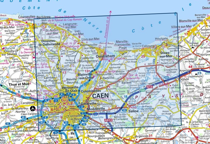
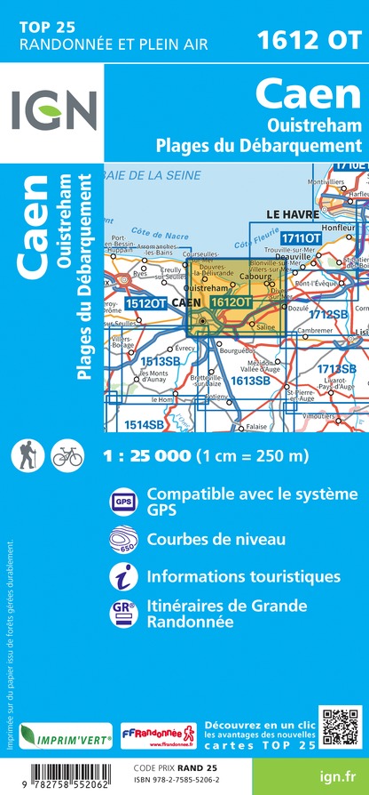
Wandelkaart - Topografische kaart 1612OT Caen - Ouistreham , Normandië | IGN - Institut Géographique National (9782758552062)

- ISBN / CODE: 9782758552062
- Editie: meest recente versie
- Schaal: 1:25000
- Uitgever: IGN - Institut Géographique National
- Soort: Topografische kaart, Wandelkaart
- Serie: Top 25
- Taal: Engels, Frans
- Uitvoering: Papier
- Bindwijze: -
- Schrijf als eerste een review
-
€ 16,95
Op voorraad. Voor 17.00 uur op werkdagen besteld, morgen in huis in Nederland Levertijd Belgie
Gratis verzending in Nederland vanaf €35,-
(10).jpg)
-
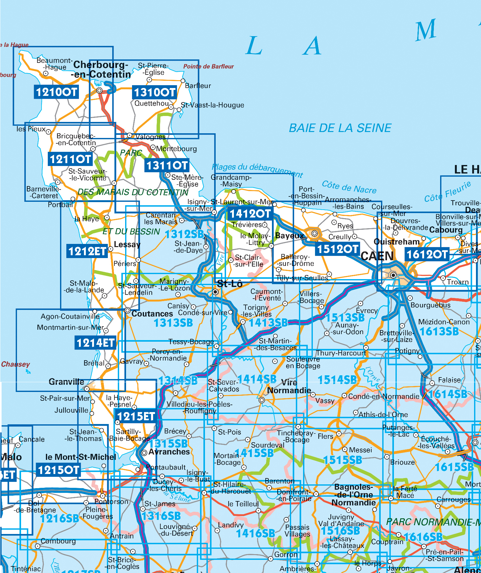
Topografische kaarten IGN 25.000 Normandië: West

Producten op deze overzichtskaart:
Klik op een product om naar de pagina van dat product te gaan.
- Wandelkaart - Topografische kaart 1210OT Cherbourg-en-Cotentin, Cap de la Hague | IGN - Institut Géographique National
- Wandelkaart - Topografische kaart 1211OT Les Pieux, Barneville, Carteret | IGN - Institut Géographique National
- Wandelkaart - Topografische kaart 1212ET La Haye-du-Puits Lessay | IGN - Institut Géographique National
- Wandelkaart - Topografische kaart 1214ET Granville, Coutances, Iles Chausey | IGN - Institut Géographique National
- Wandelkaart - Topografische kaart 1215ET Avranches, Granville, Le Mont Saint Michel | IGN - Institut Géographique National
- Wandelkaart - Topografische kaart 1310OT Cherbourg, Pointe de Barfleur | IGN - Institut Géographique National
- Wandelkaart - Topografische kaart 1311OT Valoges - Ste-Mère-Eglise Utah Beach | IGN - Institut Géographique National
- Wandelkaart - Topografische kaart 1312SB Carentan - Periers | IGN - Institut Géographique National
- Wandelkaart - Topografische kaart 1313SB St-Lô - Coutances | IGN - Institut Géographique National
- Wandelkaart - Topografische kaart 1314SB Villedieu-les-Poêlles, Gavray | IGN - Institut Géographique National
- Wandelkaart - Topografische kaart 1315SB Brécey - Ducey - Avranches | IGN - Institut Géographique National
- Wandelkaart - Topografische kaart 1412OT Pointe Du Hoc - Omaha Beach | IGN - Institut Géographique National
- Wandelkaart - Topografische kaart 1413SB Condé-sur-Vire, Caumont- sur-Aure | IGN - Institut Géographique National
- Wandelkaart - Topografische kaart 1414SB Vire Normandie, Souleuvre en Bocage | IGN - Institut Géographique National
- Wandelkaart - Topografische kaart 1415SB Tinchebray - Bocage | IGN - Institut Géographique National
- Wandelkaart - Topografische kaart 1416SB Le Teilleul | IGN - Institut Géographique National
- Wandelkaart - Topografische kaart 1512OT Bayeux Arromanches Les Bains Plages - Normandië | IGN - Institut Géographique National
- Wandelkaart - Topografische kaart 1513SB Aunay-sur-Odon | IGN - Institut Géographique National
- Topografische kaart - Wandelkaart 1514SB Condé-sur-Noireau | IGN - Institut Géographique National
- Wandelkaart - Topografische kaart 1515SB Flers | IGN - Institut Géographique National
- Wandelkaart - Topografische kaart 1516SB Domfront | IGN - Institut Géographique National
- Wandelkaart - Topografische kaart 1612OT Caen - Ouistreham , Normandië | IGN - Institut Géographique National
- Wandelkaart - Topografische kaart 1616SB La Ferté-Macé, Pré-en-Pail, Carrouges | IGN - Institut Géographique National
-
Wandelkaarten IGN 25.000 Normandië: West

Producten op deze overzichtskaart:
Klik op een product om naar de pagina van dat product te gaan.
- Wandelkaart - Topografische kaart 1210OT Cherbourg-en-Cotentin, Cap de la Hague | IGN - Institut Géographique National
- Wandelkaart - Topografische kaart 1211OT Les Pieux, Barneville, Carteret | IGN - Institut Géographique National
- Wandelkaart - Topografische kaart 1212ET La Haye-du-Puits Lessay | IGN - Institut Géographique National
- Wandelkaart - Topografische kaart 1214ET Granville, Coutances, Iles Chausey | IGN - Institut Géographique National
- Wandelkaart - Topografische kaart 1215ET Avranches, Granville, Le Mont Saint Michel | IGN - Institut Géographique National
- Wandelkaart - Topografische kaart 1310OT Cherbourg, Pointe de Barfleur | IGN - Institut Géographique National
- Wandelkaart - Topografische kaart 1311OT Valoges - Ste-Mère-Eglise Utah Beach | IGN - Institut Géographique National
- Wandelkaart - Topografische kaart 1312SB Carentan - Periers | IGN - Institut Géographique National
- Wandelkaart - Topografische kaart 1313SB St-Lô - Coutances | IGN - Institut Géographique National
- Wandelkaart - Topografische kaart 1314SB Villedieu-les-Poêlles, Gavray | IGN - Institut Géographique National
- Wandelkaart - Topografische kaart 1315SB Brécey - Ducey - Avranches | IGN - Institut Géographique National
- Wandelkaart - Topografische kaart 1412OT Pointe Du Hoc - Omaha Beach | IGN - Institut Géographique National
- Wandelkaart - Topografische kaart 1413SB Condé-sur-Vire, Caumont- sur-Aure | IGN - Institut Géographique National
- Wandelkaart - Topografische kaart 1414SB Vire Normandie, Souleuvre en Bocage | IGN - Institut Géographique National
- Wandelkaart - Topografische kaart 1415SB Tinchebray - Bocage | IGN - Institut Géographique National
- Wandelkaart - Topografische kaart 1416SB Le Teilleul | IGN - Institut Géographique National
- Wandelkaart - Topografische kaart 1512OT Bayeux Arromanches Les Bains Plages - Normandië | IGN - Institut Géographique National
- Wandelkaart - Topografische kaart 1513SB Aunay-sur-Odon | IGN - Institut Géographique National
- Topografische kaart - Wandelkaart 1514SB Condé-sur-Noireau | IGN - Institut Géographique National
- Wandelkaart - Topografische kaart 1515SB Flers | IGN - Institut Géographique National
- Wandelkaart - Topografische kaart 1516SB Domfront | IGN - Institut Géographique National
- Wandelkaart - Topografische kaart 1612OT Caen - Ouistreham , Normandië | IGN - Institut Géographique National
- Wandelkaart - Topografische kaart 1616SB La Ferté-Macé, Pré-en-Pail, Carrouges | IGN - Institut Géographique National
Overzichtskaarten
Beschrijving
De wandelkaart die de perfectie benadert! Werkelijk alle topografische details zijn er op te vinden; van hoogtelijnen tot aan bruggetjes en allerlei wandelpaden. Daarnaast hebben de makers een flinke dosis toeristische informatie op de kaart verwerkt: campings, gites d étape, restaurants en ingetekende doorgaande wandelpaden, de grandes randonnées. Het kleurgebruik is geweldig met schaduwzijdes, bos, weiland, etc goed te onderscheiden. De kaart is uitgevoerd met raster van graden, dus deze is GPS - toepasbaar!
Reviews
Geen reviews gevonden voor dit product.
Schrijf een review
Graag horen wij wat u van dit artikel vindt. Vindt u het goed, leuk, mooi, slecht, lelijk, onbruikbaar of erg handig: schrijf gerust alles op! Het is niet alleen leuk om te doen maar u informeert andere klanten er ook nog mee!
Ook interessant voor europa/frankrijk/normandie
-

Wegenkaart - landkaart Normandie D D
€ 11,95Wegenkaarten Normandië -

Wandelgids 260 Normandie - Normandië
€ 18,50Wandelgidsen Normandië -

Wandelkaart - Topografische kaart 18
€ 17,95Topografische kaarten Normandië -

Fietsgids La cote Normande a Velo |
€ 18,50Fietsgidsen Normandië -

Reisgids Capitool Top 10 Normandie |
€ 14,99Reisgidsen Normandië